Exhibition Catalogue • Schlagintweit Collection
Himalayan Encounters
Hidden Views from 170 Years Ago
The Schlagintweit Drawings & Images in India — A Journey Through Time, Geography and Scholarship
Himalayan Encounters - Hidden Views from 170 Years Ago:
 The Schlagintweit Drawings/Images in India
You can download the catalogue's PDF copy from here
Programme
1. NEW DELHI
India International Centre, Annexe, 40 Max Mueller Marg: 21 April (Tuesday) -29 April (Wednesday) 2026, Time: 11 AM to 7 PM (Inauguration/opening lectures on 21 April)
2. DEHRADUN
Doon Library and Research Centre, Dehradun: 1 May (Friday) - 8 May (Friday) 2026 (Inauguration/opening lectures on 1 May)
3. NAINITAL
CRST Inter College, Mallital, Nainital: 12 May (Tuesday) - 18 May (Monday) 2026 (Inauguration/opening lectures on 12 May)
© PAHAR and all German Institutions involved
PAHAR's Foreword
When, a decade back, I was invited by Prof. Hermann Kreutzmann of Free University, Berlin, to speak on Himalayan Explorations and he took me to the Alpines Museum at Munich to speak on Pundit Nain Singh Rawat, I was thinking about listening and knowing more about Alexander von Humboldt and Carl Ritter and contributions of the Schlagintweit brothers to Indian geography, topographic surveys and Himalayan studies but it was more than that. It was really a new beginning for Pahar and me.
Madam Stephanie Kleidt, who curated, designed and implemented the exhibition, very kindly arranged a meeting in the ‘Staatliche Graphische Sammlung’ in Munich, where many drawings were kept in high care. I may be among the very few or first fortunate Indians who saw the drawings, sketches and paintings of Nainital and the surrounding areas of Kumaon, higher Himalayan scenes and sacred places from the mid-nineteenth century in high quality and original great detail. Though I have seen the Schlagintweit volumes at the Survey of India in Dehradun and the Sven Hedin Foundation in Stockholm, and had a sense of their larger Himalayan documentation.
Immediately, a dream started twinkling about how we can do an exhibition of some of these images in our country and present the connection that happened more than one and a half centuries ago. It was really a difficult dream. Continuous involvement and initiatives of Hermann and Stephanie made it possible, and we are in the first phase organising the exhibitions with opening lectures at three places- India International Centre, Delhi; Doon Library and Research Centre, Dehradun; and CRST College/ RST Uttarakhand Academy of Administration, Nainital.
We from Pahar express sincere thanks to ‘Alpines Museum’, the ‘Staatliche Graphische Sammlung Muenchen’, the Bavarian State Library, members of the Schlagintweit family and the institutions-organisations-sponsors-individuals, who contributed towards hosting the exhibitions in India. We thank Prof. Hermann Kreutzmann, Madam Stephanie Kleidt, Dr. Johannes Erichsen, Stefan Ritter and others in these institutions for such a deep interest and regular support for this exhibition in India.
We are also grateful to I.I.C. and its President, Mr. Shyam Sharan (and others at IIC); German Embassy, Ambassador Mr. Philipp Ackermann, Delhi; D.L.R.C., its Chairman Prof. B.K. Joshi, Hon. Director, Mr. N. Ravi Shanker, Mr. N.S. Napalchyal, Mr. C.S. Tiwari and Mr. Nicholas Hoffland, Mr. Lokesh Ohri (Humanity Himalay), Mr. Sanjeev Chopra and the entire Team of VoW, Dehradun; Mr. B.P. Pandey, D.G., RSTUAA, Mr. Anup Sah, Manager/ Mr. Manoj Pande, Principal, CRST College, Nainital. Our sincere thanks to UCOST, Dr. D. Pant and Dept. of Tourism, Mr. D. Garbyal, Govt of Uttarakhand for support.
Pahar team members are working behind. Thanks to them and to Mr. S. Joshi and Smt. Usha Kashyap, who did a lot in a little given time in printing the catalogue and the calendar.
Shekhar Pathak for PAHAR Team 21 April 2026
Acknowledgements
To present the Schlagintweit paintings for the first time in India is due to many coincidences and initiatives in Germany and India. The Schlagintweit brothers and their Indian collaborators have proven a fruitful cooperation during their collaboration, an early example of Indo-German scientific cooperation in the fields of geology, geography and landscape studies. The idea for the Indian exhibition was born in September 2015 when Prof. Shekhar Pathak visited Munich during a symposium highlighting the Schlagintweit expeditions in the framework of a major display of their collected artefacts, masks, ethnographic items, maps, measurements and recordings. The central theme was the display of the Schlagintweit paintings in the context of their expeditions. The paintings had been donated by heirs from the Schlagintweit family to the Alpines Museum in Munich.
On this very occasion, Shekhar Pathak represented Indian scholarship during the symposium and was interested to see more of the Schlagintweit paintings and especially the ones from the archives. The art historian Stephanie Kleidt, the mastermind behind curating, designing and implementing the exhibition, arranged a meeting in the ‘Staatliche Graphische Sammlung’ in Munich, where many surprise findings were held in stock. For the first time, he saw drawings of Nainital and surrounding areas of Kumaon from the mid-nineteenth century in high quality and great detail. Immediately, the idea was conceived that these paintings should be shown in India to make an interested public and academic institutions aware of the wealth of information that is contained in these images made 170 years ago.
It took more than a decade to implement this idea with exhibitions in New Delhi, Dehradun and Nainital, and hopefully many other places. The efforts of the editors of this volume resulted in small grants from the Free University Berlin, the Ernst-Reuter-Gesellschaft, Berlin, and donations from Schlagintweit family members. All these are gratefully acknowledged. Other institutions and persons were instrumental in implementing the project. It required diplomatic skills and professional determination by all participants from academia and practice, from art history, history and geography, from independent commitment of retirees and people- and student-oriented associations in civil society and institutions from higher learning to convince the keepers and owners of the ‘Schlagintweit paintings- the ‘Alpines’, the ‘Staatliche Graphische Sammlung Muenchen’, the Bavarian State Library and members of the Schlagintweit family – as well as the institutions and organisations hosting the exhibitions in India. The whole team is grateful to all donors and sponsors, hosts and supporters and all invisible activists and professionals contributing in the preparation of the Schlagintweit paintings exhibition project in India.
Dr. Johannes Erichsen, Stephanie Kleidt, M.A., Munich
and
Prof. Hermann Kreutzmann, Berlin
1. Introduction – Hidden views of the Himalayan belt 170 years after
Sketching the Himalayas 170 years ago was an exploratory endeavour strongly embedded in its contemporary thinking, knowledge-generation, geographical curiosity and geopolitical interests. The mid-nineteenth century is characterised by advancements in spatial measurements, geographical surveying, technology development and atmospheric recording instruments. Geographical exploration and scientific advancement were a cosmopolitan affair and the Schlagintweit expeditions are ample proof of such a quest for augmenting existing knowledge. Their endeavour was embedded in the accumulated knowledge from earlier travelogues and manuscripts, historical narratives and tales. The cosmopolitan approach was not limited to knowledge-generation. The expedition teams themselves were composed of people from various backgrounds and origins; the sponsors and clients were not limited to one or the other country.
The innovative techniques of capturing landscapes and environmental features, recording archaeological artefacts and cultural sights had been pencil sketches and water colours, while photography was still in its early stages. The Schlagintweit images, now displayed for the first time in India since their thematic conception 170 years ago, fall into the category of parallel structures of recording, i.e., sketching with pencils, drawing with oil and water colours, and photographing and hand colouring. Their interest in geographical artefacts and features is reflected in the themes of the exhibition. The landscape paintings are covering the whole range of the Himalayan belt from Assam to Baltistan and Ladakh, from the Himalayan rimlands and the Khasi Hills to the Trans-Himalaya, Tibet and Bhutan.
For the foreign explorers, new and never-before-seen worlds were opened to their eyes; places of worship were significant locations that attracted numerous pilgrims and visitors whom they admired and met along their routes. The road conditions are reflected in conventional travel of their time, on boats, horseback and on foot, river passages and bridges attracted their attention; the scattered mountain settlements appear as hamlets and isolated dwellings with hitherto unseen construction principles and building techniques in challenging environments.

Fig. 1: Dal Lake by Adolph Schlagintweit, 28 October 1856 (GR 463). ‘Source: Private’
The paintings remind us of a Himalayan world (Fig. 1) that has left our perception as the dynamic change in infrastructure, settlement patterns, agricultural technologies and immigration of lowlanders into mountain communities has covered and/or extinguished previous livelihood patterns, habitats and ecological environments. The Schlagintweit expeditions took place just before the Indian Rebellion of 1857 which marks the turning point from colonial East India Company intrusions and occupations to the imperial establishment and domination of British India.
The selection of paintings for this exhibition was guided by our desire to show vanishing worlds that might act as a reminder of how fast the pace of change has been and what has been lost on its course. Some artefacts and landscape appearances have survived, while other dwellings and natural phenomena are lost forever. The Schlagintweit brothers (Fig. 2) were inspired by a view of natural features and cultural artefacts that was embedded in their German upbringing and training, as well as inspired by their professional mountain experience as geographers and geologists in the European Alps.
The guiding questions of their time were about the formation of the highest mountain systems on Earth and about clarifying and fixing the locations of known and hitherto unknown places in an exact manner so that reliable maps could be constructed and expand the world view. Scientific challenges were to grasp the monsoonal weather regimes, their influence on agricultural practices, the conditions for travelling and to a lesser degree, an enhanced knowledge about the life of mountain dwellers and communities.

Fig. 2: Robert, Hermann and Adolph Schlagintweit. Source: Illustrirte Zeitung. No. 804, 27 November 1858
The application of state-of-the-art techniques in recording and documenting was linked to the overall aim of better understanding potentialities of world regions, accessibility conditions and opportunities for exploitation. With their drawings, recordings and writings they significantly contributed to Indian geography and initiated further Himalayan Studies. Somehow their expedition and the generated results triggered further enquiries, provided fundamental insights for mountain studies and inspired their successors. Nevertheless, they were part of their contemporary world of science, influenced by their teachers and guided by their Indian companions, map-makers, information-gatherers, guides and translators.
The success of any expedition was strongly depending on what the Schlagintweit brothers called their ‘establishment’, i.e., the whole team of supporters, from guide to translator, from surveyor to map-maker, from trader to messenger, from purchasing agent to kitchen staff, from horsemen to load carrier, and many others completed the team that sometimes consisted of several hundred men. Focusing on the grandeur of the Himalaya mountains, well-known experts from Uttarakhand opened their eyes for the beauty of landscapes and relevant issues along their routes. Some members of the ‘establishment’ were trained and motivated to start their own careers as informants, surveyors, guides, translators and/or spies afterwards.

Fig. 3: Elevation model of Himalayan vegetation by Alexander von Humboldt and Heinrich Berghaus (1845)
2. The Historical Context of Geographical Exploration
The pioneering efforts of comparative and systematic mountain studies were fostered by its doyen Alexander von Humboldt. He himself had been an active field researcher in cosmopolitan teams operating in Latin America and Europe. Alexander von Humboldt became renowned for his mountain profiles (Fig. 3) that became comprehensive diagrams for grasping its complexities. The ecological layers distinguish between the densely populated and cultivated foothills and rimlands, in the belt above other environments such as forests and pastures appear and form the operating centre of mountain dwellers, higher up treeless and glaciated regions at the upper limit form the limit of the ecumene.
To complement Alexander von Humboldt’s empirical and theoretical studies of the ‘Kosmos’, Heinrich Berghaus published diagrams and maps in an atlas volume, which contains comparative diagrams for the Latin American Andes, the European Alps and the Pyrenees, for the Himalayan region he relied on the works of British botanists. This was the state-of-the art compendium on mountain studies before the Schlagintweit brothers were commissioned to set-off for India and to enhance the geographical knowledge about High Asia.

Fig.4 & 5: Baron Alexander von Humboldt (1769-1859) and Carl Ritter (1779-1859).
Reflecting on the handling of knowledge, it is important to note that from an academic point of view the work of Alexander von Humboldt and the Schlagintweit brothers provided the foundation for what was to be subsequently called comparative high mountain research. Before their endeavours there was a rather limited library of manuscripts and narratives in foreign languages as well as some travelogues from earlier explorers available spanning several centuries since Marco Polo, Ibn Battuta and Benedict Goes. No systematic and in the best sense empirical fieldwork-oriented material was available; most researchers in the ‘oriental sciences’ relied on second-hand material laid down in nineteenth century archives.

Fig. 6: Kumaon section from ‘Atlas von Asien’, Julius Ludwig Grimm (1833)
Alexander von Humboldt’s systematic empirical approach inspired his theoretical reasoning and attempt to synthesise knowledge, his ultimate goal was to find a theoretically sound geological or convincing volcanic explanation for the formation of mountains (Fig. 4). Their complex structures and manifold variations demanded sound recordings of geographic properties in terms of climate and weather conditions, geology and geomorphology, mineralogy, soil composition and vegetation cover.
The Berlin school of geography was complemented by the efforts of Carl Ritter, the great collector of historical and geographical manuscripts (Fig. 5). Carl Ritter augmented Humboldt’s conceptual approaches with extensive compilations in Berlin; he collected all literature and maps that were accessible to him, compiled multi-volume tomes of geographical descriptions and cooperated with leading cartographers to produce state-of-the-art maps. Still the access to reliable maps (Fig. 6) was rather limited prior to the Schlagintweit expeditions.
The Schlagintweit expeditions were part of a movement to gather a wealth of topographical information about the extent of empires and principalities, the topographic location and altitude of cities, oases towns, trading posts, mountain peaks, river valleys, the distribution of ethnic groups and languages etc. As Felix Driver summarised: these collections included soil and water samples, wood specimens, rocks, seeds, plants, reptiles and other animals, paper, textiles, religious artefacts and sacred texts. Often, the collectors were overwhelmed by the extent of their material and had only a few clues and theories about what to do with the data. They compiled inventories, collected ethnographic specimens, produced watercolour drawings, early photographs, topographical sketches and maps. The quality of their activities was strongly linked to the accuracy of recording topographical information, glossaries of vernacular terms and proper descriptions of objects.
The process of structuring the material was leading to what would become geographical landscape studies, in which definitions and their properties were part of a set of mutually understood standardised categories. Earlier on the densely settled lowland regions were the prime target while mountain areas were treated as thoroughfares for caravans, traders and pilgrims. People living there were marginal communities in the periphery. At the same time, their expertise and skills were required for crossing mountains and connecting empires.
In the context of the Himalayas, the pioneering work of the Schlagintweit brothers led to the geological distinction of the Karakoram as a separate mountain range from the Himalayas as hinted by William Moorcroft before. Soon, the ‘Indian Caucasus’ would become the Hindukush Mountains. The filling of ‘blank spots’ became an obsession. The Schlagintweit expeditions were setting the stage for a great effort in which their counterparts from Uttarakhand – among the ‘observers’ was Harkishen, among the ‘collectors’ were Luri, Joha, and Mohon Singh from Kumaon, and among the ‘interpreters’ were Mani Singh, Dolpa Singh and Nain Singh Rawat – provided their logistical and linguistic expertise, received training in various kinds of measurement and research practices.
3. A Collaborative Effort in the Nineteenth Century for Perceiving the Himalayan Belt
The Schlagintweit expeditions had prepared the stage for further systematic enquiries and exploration within British India and beyond. The impact and outcomes would be felt and appreciated in the decades to come. The British authorities realised the importance of ethnographic, geographical and geological knowledge gathering, the political value of background information and intelligence reports from places beyond their immediate realm in order to prevent intrusions and surprises on the borders of their sphere of influence and to identify commercial opportunities in trade and commodity exchange.
When Thomas Montgomerie set up his group of ‘native explorers’ after the fatal murder of Adolph Schlagintweit in Kashgar in 1857 and the acceleration of the Great Game it was not surprising that experienced and skilled people such as Nain Singh Rawat would play a central role in route exploration and providing topographical information for the compilation of gazetteers.
From the British intelligence and cartography centre in Dehra Dun, Nain Singh Rawat, being a Kumaoni schoolteacher, and Mani Singh, who had gained expertise in surveying when employed by the Schlagintweit brothers, were sent to explore routes, landscapes and communities in the Himalayas and Tibet. Their exploration was directed towards Tibet, and their return journey took two and a half years after they had left Dehra Dun in March 1864. Nain Singh Rawat returned to Tibet another three times in the following decade. His work was continued by his cousin Kishen Singh between 1878 and 1882.
The British Intelligence Department titled Nain Singh as ‘Pundit Number One’, who gained recognition by his superiors as an able and productive explorer. Henry Trotter termed him ‘Major Montgomerie’s original Pandit’, who was awarded the gold Medal/Patron’s Medal of the Royal Geographical Society in 1877. None of the Schlagintweit brothers was honoured in the same way as Nain Singh.
Kenneth Mason appreciated and praised Nain Singh’s report as a valuable source providing the cutting edge in the Anglo-Russian contest about Tibet: “By the date of Nain Singh’s retirement [1876] the veil had been lifted from Tibet and the surrounding countries. A glimpse had been obtained of the mysterious lands beneath. The quaint lama-ridden people and their customs became known to the world. The recent history, geography, and political conditions of the semi-independent states of Asia were revealed. The carefully compiled reports of both Montgomery and Trotter were of surpassing interest; and when it is realized that only one of all the old explorers could read or write English, and that they were enlisted on pay at Rs.16 to 20 a month, some idea of the debt we owe to those patrons of exploration may be gauged”.
The management of organised intelligence collection and map-making reached a high degree of sophistication and professionalism; its example has often been admired by outsiders and has been covered in a number of publications since. It is mainly told as a heroic tale in which a symbiosis of colonial master and ‘native explorer’ is contributing to a common good. The results of these expeditions and long journeys provided the basic information for gazetteers, route handbooks and selected publications in journals accessible to an interested readership.
4. German-Indian Scholarly Exchange and its Mediators – Explaining the Context
A brief introduction explaining how the Schlagintweit expedition was conceived, prepared and implemented. Alexander von Humboldt’s dream of geographical exploration of India was realised by his own efforts to initiate diplomatic exchanges between the British and Prussian Courts, convincing the East India Company that the Schlagintweit brothers would be the explorers to be hired. Six thematic sections will illustrate the context that made the expedition possible and led to further achievements, insights and influences. They are brief guidelines to follow the display of paintings in the course of the exhibition.
The Schlagintweit brothers – before the expedition
Hermann (1826–1882), Adolph (1829–1857) and Robert Schlagintweit (1833–1885) were sons of a successful eye specialist in Munich, Bavaria. Sent to university, the young men studied Geography and Geology. They trained their abilities by exploring the Bavarian Alps near Munich, combining state-of-the-art theoretical knowledge and practical qualification.
In 1849, Hermann and Adolph moved on to Berlin, the capital of Prussia. Berlin then had become the new centre of geographical science in Europe, thanks to Alexander von Humboldt and Carl Ritter. These men had set a new trend in geography, focused on empirical observation and the cooperation of all natural sciences to understand the real world.
The Schlagintweits became friends with Humboldt, who was impressed by their scientific competence and their experience in mountaineering. In 1852, Humboldt (aged 82) proposed to them a research task he had dreamt of for all his life: The exploration of the Himalayas. In his place, the brothers should do the work.
Humboldt presented the two young men to the King of Prussia and convinced the king to support his project. Officially, the exploration would be the king’s idea.
The men behind the Schlagintweit
Three men were crucial for the persuasion of the East India Company:
(i) Alexander von Humboldt (1769–1559) was the driving force behind the Schlagintweit expedition. On account of his famous expedition to South America (1799–1804), Humboldt was the most renowned and admired scientist worldwide. The King of Prussia listened to his advice. Humboldt at first proposed a Prussian expedition to the Himalayas. This project was blocked by the Prussian Minister of Culture. The definite proposal involved the East India Company. The EIC had ordered to chart the terrestrial magnetism of India. This work was unfinished and Humboldt proposed the Schlagintweits to complete it, including the Himalayan region.
(ii) Friedrich Wilhelm IV., King of Prussia (1795–1861) was the royal patron and a sponsor of the Schlagintweit expedition. Called ‘The Romantic on the Throne’ by contemporaries, he was interested in architecture, history and literature and he had a predilection for Indian art and poetry. The royal support for the Schlagintweits impressed the EIC’s directors.
(iii) Christian Carl Josias (von) Bunsen (1791–1860) was the Prussian ambassador to the British Court and a scholar. He had excellent contacts to the British scientific community and was the right man to transfer, with diplomatic skill, Humboldt’s ideas and the King’s wishes to the East India Company.
The Expedition, 1854 - 1857
It took two years to realize the expedition project, termed as Scientific Mission to India and High Asia, by order of the Court of Directors of the Honourable East India Company (EIC). Two Schlagintweit brothers became temporary employees of the EIC with the main task to record terrestrial magnetism in India. As an assistant, they took along their younger brother: Robert, a geographer and keen photographer. Dominated by Alexander von Humboldt’s original idea, the Schlagintweits were mainly interested in the Himalayas. Scientific work in the high mountains implied much more effort than travelling in the plains of India. The brothers decided to divide their work according to regions and seasons: Exploring the high mountains in summer, the hot plains in winter, Hermann would scrutinize the eastern, Adolph the western Himalayas. Unfortunately, the neighbouring states - Nepal, Sikkim, Bhutan, Tibet - denied the access to explorers working for Great Britain.
To get a better knowledge of the immense mountain region, the Schlagintweits travelled on separate ways along the old routes of Asian trade and pilgrimage – a total of 18,000 miles. Their staff members counted up to 100 persons. The head staff participated in the principals’ regular scientific work of measuring, drawing, reading the many instruments. The Schlagintweit acknowledged the abilities of their collaborators as Nain Singh from Milum, or the vaidya (native doctor) Harkishen from Almora.
The Schlagintweit brothers – after the expedition
When Hermann and Robert came back from India, their career seemed assured. They brought back 500 cases with specimens of natural history and ethnology. The East India Company consented to the evaluation of these objects at Berlin. She promised to give duplicates in the collections to Prussia. She would finance the work to be done and the publication of the expedition’s results. But the brothers had soon to deal with three serious blows:
– Adolph did not come back from Asia. He had made an attempt to reach Turkistan and was killed at Kashgar, in 1857. His death was a severe setback for the publication of the ‘Results’.
– the Schlagintweits lost their supporters at Berlin. The King of Prussia became seriously ill and assigned government to his brother, while bureaucracy blocked the Schlagintweit project of an ‘Indian Museum’. Humboldt died in 1859, Bunsen in 1860.
– the East India Company was dissolved after the Indian Rebellion of 1857. India became a British Crown Colony. The ‘India House Museum’ in London got new purposes of industrial promotion and was no longer interested in the Schlagintweits’ collections.
After three years of struggle, the brothers returned to native Bavaria. They were nobilitated and bought a castle for their collections. But they got no public employments with a fixed income and had to stop their costly publications. They began to sell their collections to museums. Both did not marry, had no children and died early.
The Schlagintweit drawings
Today, the drawings of Indian landscapes, glaciers, trees and buildings are the most interesting part of the Schlagintweits’ legacy. They give an idea of the state of Indian landscape and development in the last years of Company Rule in India. The brothers brought back to Europe hundreds of drawings. Their ‘General Register’ (GR) counts 750 motifs, 420 thereof still existing. More than half of the original stock had illustrated the Himalayas. Most of the drawings had been rapid sketches by pencil or pen, originally intended to remind important sceneries or complex details (Fig. 7). But soon the brothers understood the drawings as works of art, necessary to illustrate the different publications they planned. To adjust to the high contemporary standard of European book illustration, the drawings had to be completed and coloured. This was mostly done by a group of landscape painters at Munich, whose manners can be identified by close inspection.
Fig. 7: Sketch of a lost drawing of Nainital. Source: Drawn by Adolph Schlagintweit 18 May 1855; Alpines Museum Muenchen (related to GR 414)
The Schlagintweits took a lot of notes explaining their drawings. Not to deface the originals, the authors did rapid copies of them, which could be annotated in the right places. Some hundreds of those copies, preserved at the Bavarian State Library, help to understand the scientific content of the drawings today.


Fig. 8: Srinagar and the Dal Lake conceived for the Prussian Court in 1822 by Carl Frietrich Schinkel
Romanticism or Realism?
The French Revolution’s impact on states and societies of Europe forced 19th century artists to adapt to changing sensibilities of the public. The rational thinking of 18th century Enlightenment became superseded by Romanticism, a movement interested in History and Poetry, Religion and Sentimentality. Orientalism was an important undercurrent among the Romantics. A fine example of German Orientalism was the Berlin Opera ‘Nurmahal or the Rose Festival of Kashmir’ by Gasparo Spontini (1822). It staged poetry, love and intrigue at the Moghul court, situated in Shalimar Bagh on the Dal Lake at Srinagar. The Berlin designer Carl Friedrich Schinkel had created the decor. His Dal Lake was a poetic dream of Kashmir as oriental paradise (Fig. 8). The drawing shown here was done by Schinkel himself as a souvenir for Prince Friedrich Wilhelm IV. It certainly met and stimulated the future king’s perception of India.
Romanticism was discredited by the European Revolutions of 1848. Realism became the motto of the new period. A younger generation of artists focused on the real world and society.
The Schlagintweits were a part of this realist movement. Neither did they romanticise their views like so many artists had done nor did they criticise questionable, human interferences. Adopting the strictly objective view of the scientist, they documented Himalayan nature as close as their itinerary permitted.
5. Pundit Nain Singh Rawat – Explorer Extraordinaire
There has been some work done in the field of history of exploration in Asia. However, Indian explorers of the colonial period are unknown or lesser known as compared to others, even today. Pundit Nain Singh Rawat (1830-1882) was one of the greatest explorers of the 19th century – he did exploration work in Tibet, Central Asia and the Tartary region. He started his career as a coolie with the Schlagintweit brothers and later he worked in the Survey of India as an ordinary surveyor. He soon emerged as one of the pioneers of Indian Surveys. This article has been written in the 150th year of his first Trans- Himalayan expedition.
Nain Singh was originally from Milam village (Johar region of present-day Indo-Nepal border district of Pithoragarh, in the state of Uttarakhand, India). Milam was a Sauka or Johari settlement, situated near the Milam glacier in the higher Himalaya and en route to Untadhura and Kingri Bingri passes which led to Gyanima mart in Western Tibet. His father, Lata Burha or Amar Singh (1795-1848), for personal reasons had to leave the Milam village and settle in a non-Sauka (Bhotia) village named Bhatkura with his two wives (Nitwali and Lakhma Biljwal), near Madkot in the lower Johar. Lata was 24-25 years old at that time.
He settled here after losing a court case and his ancestral property in Milam. Both his wives committed suicide by jumping in the Gori River. Sauka women rarely did such things. This was in the year 1824; Lata was 29 years old. There was no hope of remarriage because no Johari or Marchha-Tolchha would give their daughter to Lata.
However, in the following year Lata married Jasuli, daughter of Jumal Rana (of Jumma village near Tawaghat in ParganahAskot). His eldest son Samjang was born in 1826, and Nain Singh, on 21 October 1830. While a daughter was born in 1833, the youngest son, Maga, was born in 1836. After giving birth to four children and completing 13 years of married life, Jasuli died in May 1838. She spent all her married life in Bhatkura. In the words of Nain Singh, “his father had to marry for the fourth time to bring up his four children”. Lata now married Padima, daughter of Thola Dhapwal of Dhapa village in 1839. From this wife were born Gajraj (1839) and Kaliyan (1841). Kaliyan also became a surveyor in Survey of India.
Actually, Bhatkura, a non-Sauka village, was the birthplace of Nain Singh and he was born from a non-Sauka mother. However, the fourth marriage of Lata with Padima shows that the Saukas had later accepted him. Though he did not get his ancestral property back, the slightly changed attitude of his clan gave him the opportunity to go back to Milam in 1847 after an absence(vanvas) of 27 years, where he died the following year, in social and financial difficulties.
Back to the roots. Nain Singh in Milam
It was Nain Singh’s good fortune, that their father, before his death, was able to bring his family back to their roots. None of Lata’s progeny was born in Milam as is claimed by colonial writers. Nain Singh’s first diary gives details about his mother, his birthplace, his date of birth and his own difficult childhood. His coming back to Milam also repeatedly reopened old social and family wounds. They (the rest of the Lata family) always reminded the children about what their father had done. Some of the cousins and the villagers neither forgot nor forgave Lata even after his demise. However, it is also true that some of them, like Mani Burha, were sympathetic towards Nain Singh and his siblings.
Milam was one of the biggest human settlements in Kumaon in those years and Bhatkura was a tiny village. Milam was next after Almora and three other towns in terms of population in British Kumaon, a very busy trade centre between June and October, and the last halting village before reaching Western Tibet. The Saukas of this area were keen traders and sole controllers of the Indo-Tibetan trade through the passes of British Kumaon.
In those days, there was no possibility of getting an education in this distant part of Kumaon. The early death of his parents created problems for Nain Singh and his brothers. An older cousin, Mani Burha, helped Nain Singh and suggested that he should begin some trade. Before joining any trade, he suddenly left home in July 1851, one day after quarrelling with his stepmother. In his first ever journey from Milam, he went to Mana via Munsyari, Danpur, Badhan, Himni, Balan, Irani, Pana, Joshimath and Badrinath. This was the first time that Nain Singh had crossed bugyals (alpine pastures) like Manatoli, Aali, Bedini, Kunwari, and Gaursu and rivers like Gori, East Ramganga, Saryu, Pindar, Kail, Birahi, Nandakini, Alaknanda and Vishnuganga.
The Joharis had been marrying into the Marchha and Tolchha clans of Dhauli Ganga (Niti) and Vishnu Ganga (Mana) valleys. At Mana village, Nain Singh started staying with Latadev Marchha, a well-known trader of the valley. Latadev’s daughter Lati was married to Nain’s elder cousin Mani Burha. After some time, Nain Singh got married to Umti, daughter of late Nirola and the niece of Amardev Marchha. Nain Singh remained at Mana until early 1854. It is very likely that he may have gone to Tibet and to the winter settlements of the Marchhas in those years though he has not mentioned that in his diary. He felt staying permanently at his sasural (in-laws house) was insulting or below his dignity, although Amardev had made him agree that he would continue to live with him. Amardev had promised his brother’s and his rights and share of property to Nain Singh. In March 1854, Nain returned to Milam with his 13-year-old wife (he calls her ‘Kabeelay’ in his diary) without informing his in-laws.
His stepmother and brothers were happy at his return but his being unemployed was a concern. The problems that existed when Nain Singh had left home remained unresolved. To those was added the well-being of Umti who was from a well-to-do family and for her, going to Milam was difficult in the beginning. Mani Burha had anyway been fond of Nain Singh and now a new relationship had been forged, for Umti was the first cousin of Mani Burha’s wife.
Within less than a fortnight’s stay at home, on 15 April 1854, the 24-year-old Nain Singh, with financial support from Mani Burha and others, started on a journey with Jeeta Jangpangi and Beeju Dharamsaktu to different regions of Bharmor, Punjab Hills (Himachal) to purchase sheep, goats, horses, yaks and other domestic animals. It was the longest journey he had undertaken. After crossing over the long foot hills they reached Bharmor. He saw the temple of Trilokinath on the left bank of Chandra-Bhaga (Chinav) river. The temple was built in Indian style with a marble statue of Buddha. The religious rituals were performed in the traditional Tibetan way. As in other regions of the border areas, it was a shared cultural legacy, still very much visible in all Indo-Tibet border areas.
They purchased more than 361 animals – 350 sheep and goats, 10 yaks and a horse. They returned to Keylong via Baralacha Pass, Spiti, and then entered Tibet (Sumgal and Tholing). In Tholing, he met his father-in-law, Amardev Marchha, who taunted him for leaving Mana without telling him. He gifted him a horse to make amends, as this was one of the ways of compensating social insults.
Unfortunately, on the return journey one third of the animals died near Tholing, due to a disease known as maan (rinderpest) and only around 100 survived. However, this journey helped him in his future expeditions. But his debts mounted - even managing food and clothing was difficult at home and in addition, the family and community did not treat them respectfully. His step-mother realized that the amount of the debt would continue to mount and so would the family’s difficulties. She separated from this family with her two young sons. All possessions in the house were divided into two parts and half was given to Nain Singh and his brothers and sister. Nain Singh had to look for new ways of sustenance. It was the turning point in his life.
The Schlagintweit Brothers
The Survey of India was established in 1767, 63 years before the birth of the Royal Geographical Society and Great Trigonometrical Survey which started in 1802. After that the European powers started survey work on the different continents. The great German geographer and scientist Alexander Humboldt (1769-1859), had initially suggested to the Royal Society, Royal Geological Society and Royal Geographical Society (all from Great Britain) that they should connect the magnetic surveys of the different parts of the world. The Societies submitted a memorandum to East India Company for making a new physical map of India in the light of new research and exploration. But the Company refused to accede to this request. Finally, Alexander Humboldt used his connection and requested the King of Prussia to intervene. The Company accepted the King of Prussia’s request and the three Schlagintweit brothers were given the work of surveying the Indian subcontinent.
In February 1856, Nain Singh was on his way to Ramnagar in connection with his trading activities when he heard that ‘Adolph and Hermann, Sahib Bahadurs of the Magnetic Survey’ were going to Turkistan and Ladakh. Actually, these were the noted German explorers – the three Schlagintweit brothers – Robert, Adolph and Hermann. Nain’s cousin, Mani Singh (or Patwari) was head of the helpers’ team. Nain Singh immediately wanted to go along as a porter. Initially Mani refused to take him but after some intervention, agreed. This would be another turning point in Nain’s life and in the lives of new generations of Johar.
They started from home on 28 February 1856. After travelling to Nainital, Hardwar and Nahan they reached Shimla, where Mani met the Schlagintweit brothers. Mani’s monthly salary was fixed at Rs. 60 while Nain Singh and Dolpa Pangtey would receive Rs. 35.
Mani went with Hermann Schlagintweit to Ladakh via Kanawar (Kinnaur), Piny (Spiti) and Tsomoriri (lake in Ladakh region). Dolpa Pangtey and Nain Singh accompanied Adolph and Robert from Kulu to Lahaul, crossing over the Rohtang Pass. From there Dolpa went with Adolph to Baltistan via Zanskar. Nain Singh accompanied Robert to Leh crossing over through the Baralacha Pass and Rukh Syoke. All groups stayed in Ladakh while Hermann and Robert went up to the Pushia village of Khotan near the border of Turkistan with Mani, Muhammad Amin, Maksud and Ladakhi porters. From there returned to Leh in October 1856. After crossing over the Kargil passes, they reached the Kashmir valley. Adolph also returned to Kashmir from Skardu (the winter capital of Ladakh along the Indus River).
Nain Singh’s party stayed in Kashmir for some time and proceeded to Punjab. In December 1856, the group reached Rawalpindi via Baramula along Jhelum River, where they stayed for many days. From there Adolph planned to go through Kabul, Bokhara and Russia to England.


Fig. 9: Cover of the Schlagintweit of the ‘Results’ volumes and entries about Kumaoni companions.
Hermann and Robert decided to take the sea route. All three brothers were very happy with Nain Singh. Apart from his behaviour and ability to learn fast, he taught them the Tibetan language, while from them he learnt map-making, use of instruments for measuring altitude, latitude, longitude, air-pressure, etc., and a little English. He took barometer readings and prismatic observations. A person who joined as a coolie thus became an involved technical companion.
Both Hermann and Robert wanted Nain Singh to accompany them to England (Fig. 9). Not knowing what would be the result of a foreign trip, Nain Singh initially refused to go. Crossing over the sea was a great taboo in those days. Hermann and Robert insisted, putting Nain Singh in a dilemma. He thought that if he continued to refuse, he might lose his job. Finally, Nain Singh asked Mani who got angry, probably out of jealousy. He advised Nain Singh to run away from the camp because if he went, his family would consider him dead.
Nain Singh was not yet an independent person. He could not take his own decisions so he returned after the meeting with Mani and left a long letter for the Schlagintweit brothers without meeting them in person. They were surprised and never got to know the real cause of Nain Singh’s change of mind.
Pundit (Teacher) became Pundit (Surveyor)
In 1858, Nain Singh engaged in trade again thus going to Bageshwar, which was a mid-mountain trade mart in the region. At Kapkot (enroute to Pindari glacier) he met Colonel Henry Strachey, who employed him as his servant. He knew of Nain’s participation in the Schlagintweit brothers’ expedition. Nain Singh accompanied him to Johar, Namik and Pindari glaciers. Strachey introduced him to the Deputy Commissioner of Almora, Mr. Kalvin, Education Inspector Mr. White and Col Edmund Smyth, a much-travelled military officer, who later became the Education Inspector in Kumaon.
This connection became instrumental in Nain Singh’s becoming a teacher (Pundit) in the newly established primary school at Milam in 1859. In 1862 he was given the additional charge of opening a school in the neighbouring Darma (Dharchula) patti. In Milam, his becoming teacher was opposed by some of the Milamwals (inhabitants of Milam) but he worked hard and Edmund also supported him. Nain Singh did his job well. It is surprising that a person who never saw school as a child (as there were no schools in the region where he was growing up), became the very first teacher of the first generation of educated Saukas in the Johar and Darma regions. Nain Singh disclosed his background, the debt he had, to Edmund Smith. He mentioned that the meagre salary could not enable him to pay back his old debts. Smith was unable to increase the scale so he suggested that Nain Singh join Survey of India in Dehradun for a better salary. But the nature of the work would be different. Smith had already spoken to Colonel Montgomerie about Nain Singh and Mani Singh. This connection took them to Survey of India.
In February 1863, Nain Singh, Mani and Kalyan reached Survey of India headquarters at Dehradun. They were trained in different aspects of surveying, use of instruments and collecting data. Finally, at the end of 1864, they got orders from Colonel Montgomerie to proceed to Tibet through Johar to draw maps. At that time, the Johar route was closed so they decided to go through the Kathmandu route. In January 1865, they started from Dehradun and reached Kathmandu on 13 March, 1865. They tried their best to get permission to go with a reliable party and through a safe route. At that time, the Kuti and Nialam routes were also closed due to heavy snowfall. March was too early for a clear pass.
They opted for another route. Dressed in Tibetan garments and speaking the Tibetan language, they proceeded through Kyirong carrying their instruments inside their clothes. They were stopped by a Tibetan police officer at Kyirong and were informed that the route was closed. The only alternative was to try the route through Kuti or Nialam again. The party returned to Kathmandu. At that time, Tibet was a forbidden country and Lhasa was a closed city. In those days, even traders found it difficult to reach Lhasa. At last, Mani went with a different group and Nain Singh had to accompany a Bushhar trader’s party. Nain Singh introduced himself as a Bushhari and reached Tradom in Tibet on 6 September, 1865.
From there he joined a caravan that was coming from Kashmir and going towards Lhasa. After visiting Ratung, Shigatse, Gyantse, etc., the caravan reached Lhasa on 10 January, 1866. This was the first ever Survey of India representative in Lhasa. He stayed for three months and worked on a detailed description of Lhasa. He visited Potala Palace and met 13-year-old His Holiness, the Dalai Lama. He also participated in Losar, the New Year celebrations of Tibetans (15 February, 1866) but his primary work was to study and survey Lhasa. It was not possible for him to remain under cover for long. One day two Kashmiri Muslim traders enquired and recognized that he was not a trader from Rampur Bushhar. He immediately left Lhasa on 21 April, 1866 after staying for about 100 days and crossing Gyantse and Shigatse he went westwards along Tsangpo River.
After crossing over MahemLa, he reached Darchin in Kailash Manasarovar region (the catchment area of Sutlej River) on 17 June 1866; a region where the Kumaoni Saukas had been coming for a long time in connection with trans-Himalayan trade. This was his first trip to the Kailash area, frequently visited by his community. Then he crossed over Niti Pass (crossed by William Moorcroft in 1812) as the Kingri Bigri La was full of ice and snow and after Lapthal, Topidhunga he crossed Untadhura Pass on 29 June and reached Milam. In July 1866, he returned to Dehradun and Mussoorie. Nain Singh travelled more than 2400 km, over 18 months and the mean height of the places he travelled was between 3333-5333 m above sea level. The Royal Geographical Society presented him a gold watch with an inscription in the Devanagri script. The British Government in India also honoured him.
Thokjalung: The region of gold, borax and salt mines
A year after that tiring journey, he was ordered to join an expedition to Western Tibet. The main aim was to explore the gold, salt and borax mines and collect geographical information. The journey was difficult and risky, especially because Tibetan officers knew of his previous journey. It was also possible that the Sauka traders of Kumaon in different trade centres of Western Tibet may recognize him.
The 11-member team started its journey from Mana 25 July 1867. The biggest challenge in the region was from Tibetan dacoits. Nain Singh’s party took guns and swords with them. On the way they had to cross obstacles of Tibetan officers and difficult terrain. They reached Tholing, one of the important cultural centres of Western Tibet, on 4 August, 1867. Rinchen Jangpo (Ratn Bhadra) built a beautiful monastery here in 9th-10th century and similar monasteries were replicated in later years at Tabo in the Spiti valley and other places in Himalaya. Nain Singh met his father-in-law Amardev for the second time in Tholing.
From there they started the journey towards Thokjalung and reached there on 26 August 1867. They were allowed to stay for four or five days by the hakim (officer) so they used each second of those days working. Nain Singh made a detailed report on the mines of gold, salt and borax, the mining process, the labourers and their conditions. He surveyed the whole town of Thokjalung. On their return, they surveyed the Indus and Sutlej valleys. Their survey actually becomes the connecting link between the work done by Moorcroft in Western Tibet and Cunningham in the Ladakh area.
When he returned from Mana Pass, there was heavy snowfall – he suffered from frostbite and fell ill. The party came back to Dehradun in December 1867. This was the first attempt by the Survey of India in this region. The team was able to survey the catchments of the Indus, Sutlej and their tributaries. He, for the first time, mentions the 7-8000 m Aling Kangri mountain where he met local people who ate only meat. Thokjalung expedition added one more feather to his cap. They had walked around 1700 km.
Five Months in Yarkand
The next five years were a bit restful for Nain Singh. He worked more as a teacher-trainer at the Survey of India headquarters at Dehradun and in Mussoorie. He was rewriting his diaries and notes scattered in thousands of small scraps of paper, most of which are still preserved at the Survey of India, Dehradun, and National Archives of India, Delhi. Nain Singh first worked with Montgomerie and when the latter went back to England due to bad health, Nain Singh worked with Henry Trotter. He wrote the very first vernacular primer of surveying known as ‘Akshans Darpan’ (1871) and it might be among the first scientific writings in Hindi in the second half of the 19th century.
On 14 February, 1873, Colonel Montgomerie, who had become the Deputy Superintendent of the Great Trigonometrical Survey, ordered him to conduct the survey of the unknown Tsangpo valley downstream from Lhasa. It was suggested that they should go to Sahibganj and Allahabad by train and from there to Darjeeling, Sikkim, Giangche and Lhasa. From Lhasa they were told to go along Tsangpo down to Lakhimpur, the British Indian settlement in upper Assam.
Kishan Singh was helping with preparations. They were at Almora awaiting final orders. In the first week of April 1873, the new Deputy Superintendent of Great Trigonometrical Survey, JBN Hennessey, decided to postpone the expedition. He ordered Nain Singh and Kishan Singh to reach Mussoorie to teach surveying to two new surveyors and join T Douglas Forsyth and Henry Trotter to Yarkand and Aksu region. This expedition, known as the Forsyth Mission, was actually the second Forsyth Mission and became Nain Singh’s third big expedition after joining the Great Trigonometrical Survey. Kalyan Singh, Jasmal and a few others were with this team.
The English members of this expedition were Thomas Douglas Forsyth, Henry Trotter, Edward Francis Chapman, Thomas Gordon, John Biddulph, Henry Walter Bellew and Ferdinand Stoliczka. This was the first expedition to Tibet in which English surveyors, explorers and doctors were participating. They started from Mussoorie June 1873 and from Shimla they went further, crossed over Baralacha La reaching Leh in early August. They were in Yarkand on 8 November 1873 and Nain Singh stayed there for five months. He has vividly described the region. They finally returned to Leh in May 1874.
The group with its subgroups worked in the area south and north of Karakoram range; in places like Chyanglung, Saserghati, Daulatbegi, Gyapsan, Shahidulla, Korgan, Mustaq, Kargalik, Yarkand, Aksu etc. They found a direct route from India to Turkistan, by passing the Dogra territory. This route of around 1500 km was via Najibabad-Srinagar-Joshimath-Niti-Tholing-Bogo La-Gartok-Damchok-Zara La-Rudok-Khotan.
Each member contributed to a 550-page book that was published on this expedition, one of the first documents with photographs. But there was no photo of the Pundit in this volume. The English officers however appreciated Nain Singh for working fearlessly in a geographically, climatically, geopolitically and socially difficult terrain.
Leh to Lhasa to Tawang: The last and greatest expedition
His last and the greatest exploration trek was on the north back of Himalaya – from Dehradun-Shimla-Leh to Lhasa, culminating in back journey to Samye-Tawang-Udalgudi-Guwahati-Calcutta and finally to Dehradun. The party started from Leh in July 1874. Pundit Nain Singh and his comrades dressed as lamas holding prayer wheels, chanting ‘Om Mani Padme Hum’. After crossing Noh, Pangong lake, Thokdaurakpa, at the height of 4500-5000 m above sea level, he surveyed Itisik lake. This was the area peopled by the Khampa or Changpa. They were supposed to be dangerous but he found them simple Buddhist nomadic pastoralists in a cold desert area with very little water. Once, on the way, the Khampas rushed towards their camp but it was only out of curiosity. In September 1874, they reached the gold mines of Thokdaurakpa. The mine labourers were known as fukpa and they used to live inside the manmade land caves. Kumaoni Sauka traders also brought the gold from these mines to India.
According to Nain Singh, gold costing around Rs. 80,000 annually went to Gartok mart from those mines. Every year the gold miners had to give tax of 1/5 of one ounce per person per year to a Sarpon (Gold Commissioner). Nain Singh realized that the pastoralists were in much better condition than the gold miners. On the way, he saw a tea caravan with 200 yaks, transporting brick tea to other regions, numerous sacred lakes and also met Bonpas, the pre-Buddhist Tibetans.
On 18 November 1874, eight years and 10 months later he reached the forbidden city of Lhasa. Revisiting Lhasa was a unique event in the life of Nain Singh Rawat, as no other explorers had achieved that distinction until then. However, the first person who met him was a Leh trader known to him. The news of his journey reached the Tibetan authorities in Lhasa. The trader also started blackmailing him. Nain Singh understood the situation and decided to leave the city two days after his arrival. His party, however, had to wait for money, which the British government had sent through a trader. Later, they found out that the trader had died on his way. Nain Singh opted to exit via a new route southeast of Lhasa. He sent two of his assistants to Ladakh with reports to the British Joint Commissioner of Ladakh, which reached the Survey department in January 1875.
When Nain Singh left Lhasa on 20 November 1874, he told the sarai manager that he was going on a pilgrimage and would come back within a month. As a precautionary measure, he walked towards the north in the morning and by evening towards the southeast. He crisscrossed the Lhasa-Peking Road at Dichid. After that, Nain crossed Gokhar Pass, 3340 m, which was the divider of the catchments of the Lhasa and Tsangpo rivers. In November 1874, he reached the 8th century (oldest) monastery of Samye. It was from here that Buddhism spread around Tibet and became recognized as the state religion. The monastery had four gates on each side and with golden statues, 1030 chortens, 108 sacred books (Tanjur-Kanjur) and on the walls, stanzas in the Devanagari script were carved or painted. He crossed over the Tsangpo by a boat. He threw a wooden log into the river and noted that in two minutes and 40 seconds the log floated 30 m.
At Chhetang, a place with an old monastery, he left Tsangpo, which was also visible from upper Assam. Nain was able to throw some more light on the course of the Tsangpo. He enquired and found that local Tibetans were aware that Tsangpo became Brahmputra in Assam. This is known as Dihang at Sadia in upper Assam. After that, Nain Singh crossed Dalatang La (5300 m) and reached the Drogpa pastures. After passing Karkang La (5403 m) he entered into catchments of the south flowing rivers and their glaciers. Finally, after crossing Serasa La he walked along Tawang River and crossed Mila Khatong la and Chhona Jong, a trading centre, before reaching Tawang in December 1874 where he stayed for 54 days. Tawang is famous for its large monastery and at the time of Nain Singh’s arrival, there were 600 lamas (monks) in the monastery. Finally, he reached Udalguri (close to Tezpur-Tawang route) and the Deputy Commissioner helped him to reach Guwahati. From there he reached Calcutta on 11 March 1875 by steamer and finally returned to Dehradun.
In that expedition, he travelled from Leh to Lhasa to Udalguri, around 2800 km. Of those, about 2400 kms were previously untrodden. He learnt about human geography, rivers, lakes, deserts, monasteries, glaciers, society and culture in that region and surveyed them for the first time. He noted the temperature, latitude, longitude and altitude of different places. This last trek was exhausting. Though Nain Singh was only 45 and lived for another 20 years, he was not fit for any further expeditions.
Fig. 10: Map of Nain Singh’s survey in Tibet – Lhasa section
Nain Singh had seen the mountain Nanglong Kangri, on a previous expedition and further explored it on this expedition. Later, the range was named as Nain Singh range and remained so in atlases for many decades until 1961, when geographers resolved that no natural features should be named after individuals.
Travel literature and a scientific book
Nain Singh may have never thought that what he jotted as notes and as a small book would become so important for later generations. Three diaries and a book, together known as Akshans Darpan have become important documents in the history of survey and vernacular writings in India. His fourth diary has not yet been located. The diaries tell us his personal story, the history of Johar (his region) and its different clans, the story of his parents and finally his different expeditions before and after he joined the Great Trigonometrical Survey.
They capture his sensitivity, sensibility, curiosity, communication and language skills, ability to tackle problems and finally his commitment to collect hard data and measurements. He proved many times that he could take risks but never missed his observations. And without the diaries, we would have missed most of his life and explorations.
Pundit Nain Singh — An assessment
According to our studies, Pundit Nain Singh trekked more than 16000 kms before joining the Survey Department, and as a surveyor he trekked more than 26000 kms. He discovered more than a hundred places, many rivers and lakes, mines and monasteries. He inspired great explorers such as Kishan Singh, Percy Sykes, Sven Hedin, Francis Younghusband and Rahul Sankrityayan. The Royal Geographical Society of London honoured him, he was awarded the title of CIE through the Government of India and got land as a grant near Moradabad in Uttar Pradesh.
The colonial rulers might not have wanted to make him a hero of Himalayan and trans-Himalayan explorations but it was hard for them to avoid acknowledging his contributions. Persons like Henry Yule advocated his case in the Royal Geographical Society by describing him as ‘Pundit of Pundits’, which finally became instrumental in awarding him the Victoria Medal (or Patron’s Medal) of the Royal Geographical Society. However, after his retirement nobody in the Survey of India was concerned about him. He received all his awards in absentia.
When the news arrived that Pundit was dead, no one cared to confirm it. Edmund Smyth wrote an emotionally charged and moving obituary in 1882. However, the district officers failed to confirm the news. But as per Survey of India records, he died only in 1895 – the actual date is not known. It is said that he died in village Madkot by the banks of river Gori. Both his houses are still standing - his great-great grandson was a bookseller there until a few years ago and the latter’s son is a teacher at Madkot.
In the end I must quote Henry Yule, from what he said at the Royal Geographical Society: “…Nain Singh is the Pundit of Pundits. Nain Singh’s great merits cannot be fully recognized by anything short of one of the Society’s Gold medals. Either of his great journeys in Tibet would have brought this reward to any European explorer. To have made two such journeys adding so enormously to accurate knowledge…Is what no European but the first rank of travellers like Livingstone or Grant have done… He is not a topographical automation, or merely of a great multitude of native employees with an average qualification. His observations have added a larger amount of important knowledge to the map of Asia than those of any other living man and his journals form an exceedingly interesting book of travels. It will afford me great pleasure to take steps for the transmission of the medal through an official channel to the Pundit.”
There is need to remember Nain Singh and re-evaluate his achievements today. His unique journey from a shepherd to porter, to surveyor to teacher/trainer and finally to an explorer extraordinaire should set an example for today’s lovers of Himalaya, adventurers and modern explorers.
Fig. 11: Nain Singh. Source: Records of Survey of India 1915

6. The Schlagintweit Brothers’ Itinerary in ‘India and High Asia’
Officially, the Schlagintweit brothers were employed by the East India Company (EIC) to investigate terrestrial magnetism in northern India and the adjacent high mountains, following a proposal by Alexander von Humboldt. This task had been entrusted first to the engineer Charles M. Elliot in 1846, but had been left unfinished following his untimely death in 1852. Elliot had only been able to map the seas and the southern part of the Indian subcontinent. The Schlagintweits were now to cover the missing, larger northern section.
Unofficially, however, the brothers’ expedition apparently was intended to gain more reliable knowledge about the Himalayas and the mountain ranges in the North. This was in line with Alexander von Humboldt’s wishes, which were well known in London. Furthermore, the EIC is likely to have recognised the opportunity to learn more about the physical geography of the Himalayas and its foothills as well as the network of passes, routes and trails under the guise of scientific surveys. In any case, the EIC not only supported the Schlagintweit expedition within its own dominion, but also exerted diplomatic pressure on the adjoining states of Kashmir, Nepal and Sikkim to agree to the brother’s research in these countries. Kashmir consented to this, whilst Nepal delayed its consent and Sikkim refused outright. Tibet was presumably not contacted because it generally prohibited entry of foreigners.
The Schlagintweits apparently only learnt of this refusal after their arrival in India (Fig. 12). This meant that the entire southern side of the central Himalayas would remain as inaccessible to them as the Tibetan Plateau to the north. Although Hermann was allowed to visit Kathmandu and the surrounding area in 1857, there was no time left for further studies in the mountains of Nepal. The plan, under which Hermann was to explore the eastern and Adolph the western part of the Himalayas, had to be modified.
First, however, the brothers had to link up with the data collected by Elliott in the South. From Bombay, where they set foot on Indian soil on 26 October 1854, they travelled first across the Deccan to Chennai, visiting the British observatory at Kaladghi along the way. Without studying southern India in detail, they travelled by ship to Kolkata, the administrative headquarters of the EIC, in March 1855. From there, after lengthy negotiations and the selection of the British and Indian assistants who were to accompany them, they set off in different directions. In order to explore as many areas as possible, the brothers, from then on, travelled almost always separately. Robert, who had come along as an assistant and was not so experienced, usually accompanied one of his brothers and operated the camera they had brought along. He was also responsible for packing and looking after the collections of all kinds that the brothers gathered or acquired.
In June 1855, Hermann set off northwards to the British part of Sikkim, which, situated between the independent states of Nepal, Sikkim and Bhutan, seemed to offer the chance to unobtrusively reach the Eastern Himalayas along the borders. The attempt failed due to the vigilance of the Nepalese border officials. Taking a wide detour, he travelled by boat through Bengal via Dhaka and reached the Khasi Hills in November 1855, and from there Assam. From Guwahati, he undertook a foray into Bhutan to the monastery and administrative centre of Taklung Dzong near Kalaktang (now Arunachal Pradesh), where, however, the powerful Lamas prohibited him to continue his journey to Tawang and Tibet. Hermann therefore returned to Tezpur in Assam and henceforth concentrated his interest on exploring the Brahmaputra, which he travelled up by boat as far as Dibrugarh. In February 1856, he came back to Kolkata, again by boat.
Fig. 12: ‘Routes followed by Messrs. de Schlagintweit and their Establishments’ in Schlagintweit (1861: C. Maps a) Atlas volume.
Adolph and Robert had already set off in March 1855 towards the North-West, travelling up the Ganga Valley on the Great Trunk Road. Their first destination in April was the British station at Nainital in Kumaon, where they completed their ‘establishment’ of assistants and gained their first experiences on the ground. In June, they travelled through the Nanda Devi region to Milum, intending to reach Tibet from there. In the Sutlej region, however, they were stopped by a border guard. Following negotiations with the authorities in Daba, they were finally permitted to proceed to the Sutlej and visit the monasteries of Mangnang and Tholing there. They also passed the ruins of the old capital Tsaparang, though without realising its historical significance. A push across the Sutlej took them almost as far as Gartok before they returned to British territory via the Mana Pass, attempting to climb Ibi Gamin on the way. Adolph subsequently managed, in disguise, to return once more to the forbidden Ngari Khorsum and completed his measurements and observations. During this time, Robert travelled on to Garhwal and visited the glaciers and pilgrimage sites at Badrinath and Kedarnath.
As winter was approaching, the two brothers then headed south. Adolph explored the Nilgiri Mountains and the territories of the Maharaja of Mysore and returned by ship from Chennai to Kolkata in April 1856. Robert, on the other hand, parted company with his brother in Sagar and travelled via Benares back up the Ganga to the North-West.
After being apart for more than a year, all three brothers met up again in Simla in April 1856 and coordinated their plans. As the Eastern Himalayas had been explored as far as possible and negotiations with Nepal had still remained fruitless, Hermann was free to undertake further explorations in the North-West. There, the regions of Ladakh and Baltistan, controlled by the Maharaja of Kashmir, beckoned. Turkestan, further north, appeared accessible, too. The teams were therefore reorganised.
In the summer of 1856, Hermann and Robert – the former visiting Lake Pangong en route – travelled along separate routes to Leh in Ladakh and set up base there. For the time of their absence, they installed an observation post, which was controlled by their ‘native doctor’ Harkishen. From Leh, Hermann visited the Lamaist monastery of Hemis on the Indus, where he was able to acquire important masks from the Cham dance.
From Leh, the two brothers set off for Turkistan via the Saser and Karakoram passes. To avoid being recognized, they veered off the usual caravan route after crossing the Karakoram Pass and made their way across the deserted plateau to the Karakash River on the southern edge of the Kunlun Mountains. Crossing the crest of Kunlun via the Hindutagh Pass, they were able to look down on Khotan in Xinjiang. From there, they returned to Leh via the usual route. The reconnaissance of the Kunlun Mountains and the insight that the Karakoram was a separate range and part of the main Himalayan watershed later earned Hermann the Russian honorary title ‘Sakünlünski’, meaning ‘pioneer of the crossing of the Kunlun’.
During these months, Adolph travelled via Zanskar and Skardu to Baltistan and Gilgit to study and survey the vast glaciated areas of Mustagh and the adjacent glaciers. Subsequently, he visited the mountains of the Astore Valley in the vicinity of the Nanga Parbat. In October 1856, he arrived in Srinagar for another meeting with his brothers. From there, the three Schlagintweits continued on towards the Punjab.
In Rawalpindi, the brothers learnt that Nepal had finally agreed to their visit. Hence Hermann abandoned his further plans and rushed to Nepal via the Great Trunk Road. In February 1857, he arrived at Kathmandu. He stayed there for almost four weeks, but was unable to reach the high mountains. Having returned to Kolkata, Hermann set off on his journey home in April 1857, travelling via Sri Lanka. In May 1857, he embarked for Europe from the port in Galle.
During this time, Robert was busy transporting the last crates with the Schlagintweit collections overland to Surat, from where they were shipped via Mumbai and Galle to Europe. This afforded Robert a brief last stay in Sri Lanka, where he met up with Hermann again.
What Adolph had planned for the spring of 1857 is not recorded. In any case, he must have decided to return to Europe later than his brothers. He visited the geologically significant Salt Range in the Punjab and then turned towards Lahore. From there, however, he did not explore the South-West of the British dominion, as one might have expected in view of the magnetic measurements, but veered off and turned north again. He passed by Leh and crossed the Karakoram and Kunlun ranges towards the oasis cities of the Silk Road. However, he only reached Kashgar in East Turkestan, where, in August 1857, he incidentally arrived when a Kokandi usurper had taken control who opposed against Chinese rule. The unfortunate German traveller was murdered by Wali Khan Tura who got his companions arrested, enslaved or jailed. Adolph, as an obituary put it, had become ‘a victim of his zeal’. Two brothers returned to Germany and Adolph found his grave in Kashgar.

7. Catalogue
Preliminary remarks on the selected drawings and catalogue entries
The vast majority of still existing Schlagintweit drawings ‘from India and High Asia’ are kept by different private and public collections at Munich, Germany.
The Staatliche Graphische Sammlung Muenchen
(= State Collection of Prints and Drawings, Munich) holds drawings deposited in the former Royal Cabinet of Prints and Drawings in 1898. The drawings were then thought to be autographs by Hermann and Adolph Schlagintweit.
The Alpines Museum Muenchen
(= Alpine Museum of the Federation of German Alpine Clubs Munich) holds drawings selected which were sold by Hermann’s heir in 1888. These are based on the original sketches, but were mostly finished, augmented and/or even copied by selected Munich landscape painters. A significant number was later repurchased by the Schlagintweit Family and eventually donated to the Alpine Museum in 2013.
The Bayerische Staatsbibliothek Muenchen
(= Bavarian State Library) holds the Schlagintweit papers (‘Schlagintweitiana’). This stock contains the ‘explanatory sheets’, i.e., traced outlines of the drawings with the original notes, bound in 17 volumes. Included in this collection are some 60 original drawings which the heir regarded as insignificant.
Schlagintweit Family members
still hold important drawings in private possession. Some were made available for this exhibition.
Catalogue of reproductions
Note: The reproductions on display were categorised and organised in ten thematic sections. In this catalogue they are introduced and described in greater detail, context and background information.
(1) INTRODUCTION
An official ‘General Register’ (GR) of the drawings and some photographs was published by Hermann Schlagintweit, in 1859, titled ‘Catalogue of Panoramas and Views from India and High Asia’. The GR numbers are essential for precise determination of the motifs. They are included here at the end of each entry. The GR gives dates of recording, which not always seem to be correct.
The first line of the entry gives the original title of the drawing as listed in the GR. The second line [in brackets] shows the current name of the place where the drawing was conceived. The exhibition presents reproductions in the drawing’s original format, if not otherwise stated. There are some exceedingly large drawings which had to be reduced in size.
The texts of section (1) contain historical information. Prior to the display of Schlagintweit pictures a watercolour by Carl Friedrich Schinkel from 1822 is shown, which depicts an opera scenery for ‘Nurmahal’ by Gasparo Spontini conceived at Berlin a generation before the Schlagintweit brothers came to India (Fig. 8). The romantic phantasy inspired and reflected European attributions and perceptions of India and probably motivated Adolph and Hermann Schlagintweit to present their realistic and scientific drawing of the Dal Lake and its environs to the Prussian King.
Romantic Phantasy: Srinagar and the Dal Lake, seen from Shalimar Bagh
Second scene of the opera ‘Nurmahal’ by Gasparo Spontini. Carl Friedrich Schinkel, Berlin 1822. Kupferstichkabinett SPK, Berlin (SM 22d.177)
Schlagintweit Collection
1
The Northern part of the Lake of Kashmir
[DAL LAKE, NORTH-EASTERN PART, SRINAGAR, JAMMU AND KASHMIR]
Watercolour over pencil on paper. Adolph Schlagintweit, 28 October 1856. Private Property, Munich (GR 463)
This sheet is the ‘northern’ half of a wide panorama Hermann and Adolph Schlagintweit painted simultaneously, back-to-back, during their brief stay at Srinagar. The views of this most famous lake of all India were probably painted for King Friedrich Wilhelm IV of Prussia, whose interest in the lake and the adjacent Shalimar Bagh was certainly known to them.
(2) NAINITAL AND ITS MOUNTAINS
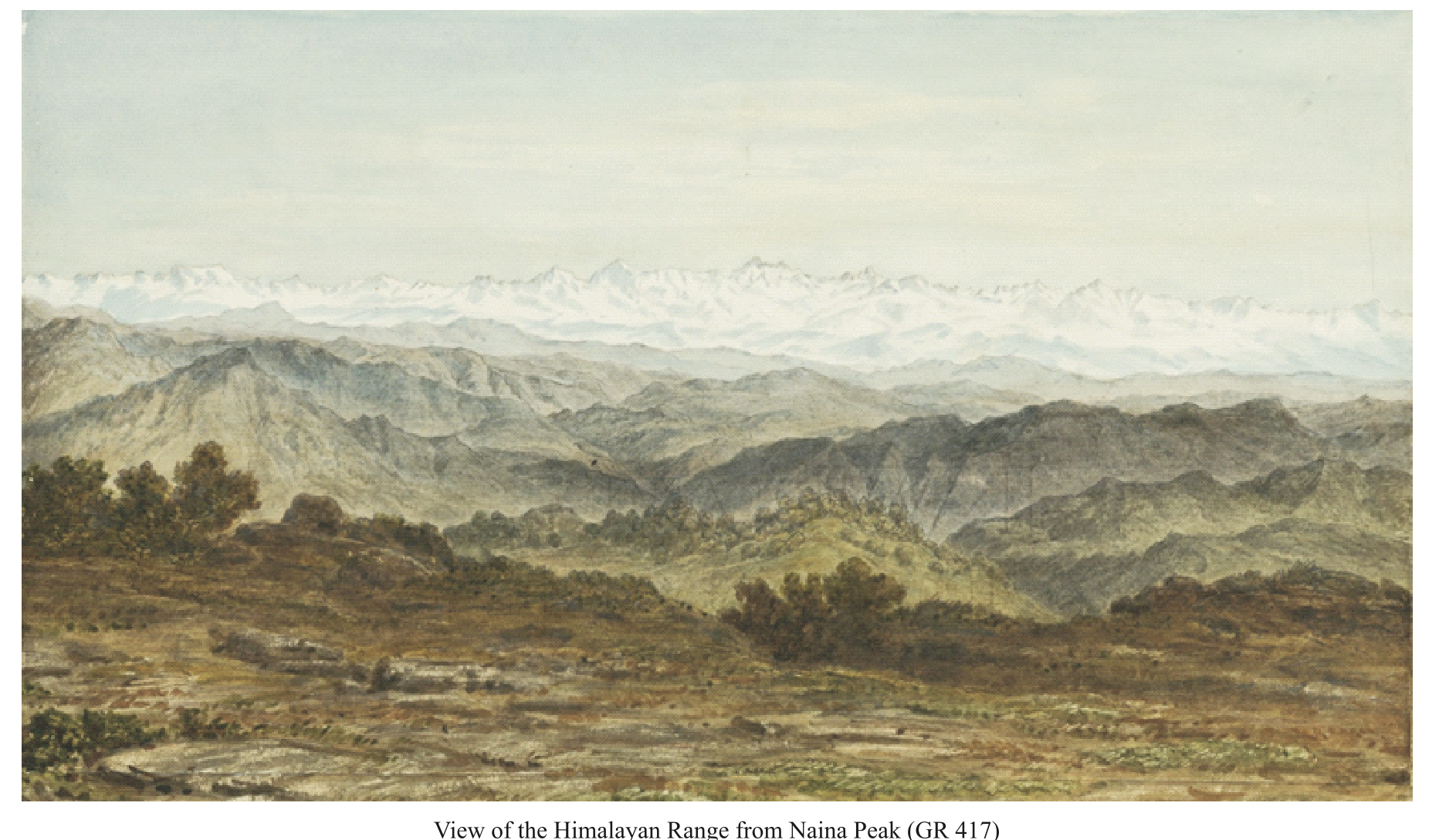
Nainital was the place of Adolph and Robert Schlagintweit’s first personal experience seeing the impressive Himalayan Range. The brothers stayed at the British Station from mid-April to mid-May 1855, exploring the complex geological structure of the Himalayan region. The explanatory sheets belonging to the drawings document Adolph’s scientific ambitions. A prolonged stay on the Chiner [China or Naina peak, 2,615 m] provided a good overview of Nainital and the sequence of peaks resulting in the very first drawing of their Himalayan panoramas.
Above all, Adolph admired Nainital’s abundant verdant vegetation. In a letter to Alexander von Humboldt, dated 17 May 1855, he praised it as “surprisingly beautiful: The magnificent oaks at Tschinnur [Chiner] peak and the lush fresh green of the trees covering the slopes certainly will not be found anywhere in the Alps in a more impressive form. The Rhododendron trees, full of red blossoms when we arrived here, give the scenery a very peculiar, rich character.”
2 – Station and Lake of Nainital [NAINITAL, UTTARAKHAND]. Photograph by Robert Schlagintweit, 27 April 1855, coloured by Hermann Schlagintweit. Staatliche Graphische Sammlung Muenchen (41795 Z; GR 414)
3 – Lake of Nainital with the Spurs to the Plains [VIEW FROM CHINER PEAK]. Adolph Schlagintweit, 23 April 1855. Watercolour over pencil on paper. Bayerische Staatsbibliothek Muenchen (GR 415)

4 – Himalaya Ranges from Chiner Peak [THE HIMALAYA FROM NAINA PEAK, NAINITAL]. Adolph Schlagintweit, 29 April 1855. Watercolour over pencil on paper. Alpines Museum Muenchen (GR 417)
5 – Outer Himalaya from Leria Kanta [VIEW TO THE PLAINS FROM LARIYA KANTA]. Adolph Schlagintweit, 7 May 1855. Alpines Museum Muenchen (GR 418)
6 – The Chiner Summit from Leria Kanta [NAINA PEAK SEEN FROM LARIYA KANTA]. Adolph Schlagintweit, 9 May 1855. Private Property, Muenchen (GR 419)
7 – Cleavages on the southern Slope of Chiner [NAINA PEAK, NAINITAL]. Adolph Schlagintweit, 27 April 1855. Brown wash over pencil on paper. Bayerische Staatsbibliothek Muenchen (GR 420)
8 – The Summit Leria Kanta from Sher ka Daanda [LARIYA KANTA SEEN FROM SHER KA DANDA]. Adolph Schlagintweit, 16 May 1855. Alpines Museum Muenchen (GR 421)
(3) BALTISTAN AND LADAKH
Both regions were dominated by Gulab Singh, the Maharaja of Jammu and Kashmir, since the Treaty of Amritsar in 1846. Ladakh, located in the arid high mountain zone between the fertile Kashmir Basin and the Silk Road oases of Xinjiang was an important entrepot on the trade routes between India and Inner Asia. The high mountain assemblage of Baltistan attracted Adolph, the Schlagintweit brothers’ glacier specialist.
9 – Tibetan Houses in Leh, in the Northern Part of the Town [HOUSES NEXT TO STAGOPILOG STUPA GATE, LEH]. Hermann Schlagintweit, 2 October 1856. Alpines Museum Muenchen (GR 348)
 Lamayuru Monastery (GR 271)
10 – The Gonpa or monastery of Lama Yuru in Ladak [LAMAYURU MONASTERY]. Hermann Schlagintweit, 6 October 1856. Alpines Museum Muenchen (GR 271)
11 – Hot Springs below Vaka in Dras [MULBEKH HOT SPRING]. Hermann Schlagintweit, 7 October 1856. Alpines Museum Muenchen (GR 596)
12 – Gushka Dar, left Side of Chandrabhaga Valley [JUNCTION OF CHANDRA AND BAGHA RIVERS IN GUSHAL]. Adolph Schlagintweit, 13 June 1856. Alpines Museum Muenchen (GR 458)
13 – The Padum Basin seen from the ancient Moraines of Haptal-Glacier [PADUM IN ZANSKAR]. Adolph Schlagintweit, 27 June 1856. Alpines Museum Muenchen (GR 512)
14 – Valley of the Shayok near Khabulu [THE SHYOK VALLEY NEAR KHAPLU]. Adolph Schlagintweit, 12 July or 1 August 1856. Alpines Museum Muenchen (GR 527)
15 – Indus Valley near Skardo from Gulab Singhs New Fort [OLD FORT SKARDU, BALTISTAN]. Adolph Schlagintweit, September 1856. Alpines Museum Muenchen (GR 540)
(4) ASSAM AND KHASI HILLS
Hermann Schlagintweit pursued the recording of terrestrial magnetism in the North-East of India. During the monsoonal season of 1855, he travelled to one of the oldest British stations: Cherrapunji in the Khasi Hills. Hermann was not only interested in geographical phenomena such as the extreme precipitation patterns and the abundant hill vegetation, but Khasi history and architecture fascinated him as well.
16 – Foot of the Khassia- and Jaintia Hills from the Surma River. Hermann Schlagintweit, 20 September 1855. Staatliche Graphische Sammlung Muenchen (24905 Z)
 View from Khasi Hills to Jaintia Hills (GR 79)
17 – The Jaintia Ranges, from the West [VIEW FROM KHASI HILLS TO JAINTIA HILLS]. Hermann Schlagintweit, 4 October 1855. Alpines Museum Muenchen (GR 79)
18 – Khassia Stone-Pillars and -Tables at Cherrapunji [KHASI MONOLITHIC MONUMENTS]. Hermann Schlagintweit, 28 October 1855. Alpines Museum Muenchen (GR 259)
19 – Telescopic View of Giants Peak in Bhutan from Gohatti [BHUTAN PEAK SEEN FROM GUWAHATI]. Hermann Schlagintweit, 19 November 1855. Alpines Museum Muenchen (GR 599)
(5) TRANS-HIMALAYA
Exploring the Himalayan Mountain range called for inspecting its northern side as well. While its southern slopes were within the realm of the East India Company, political tensions and travel restrictions by the Tibetan rulers barred foreign explorers and traders from entering Tibet. Their only option was to travel in disguise.
20 – The Tibetan Slope of the Himalaya in the Environs of the Niti Ghat. Adolph Schlagintweit, 18 July 1855. Private Property, Muenchen (GR 474)
21 – The Satlej near Camp Dulla Sumda [SUTLEJ, NGARI PREFECTURE]. Adolph Schlagintweit, 31 July 1855. Staatliche Graphische Sammlung Muenchen (41848 Z; GR 480)
 Tholing Monastery (GR 493)
22 – View of Toling in the Sutlej Valley [THOLING, TODAY ZANDA, NGARI PREFECTURE]. Adolph Schlagintweit, 12 September 1855. Alpines Museum Muenchen (GR 493)
23 – Dervasa Sultan Chuskun, at the Junction of the Kissilab and the Shayok. Hermann Schlagintweit, 7 September 1856. Alpines Museum Muenchen (GR 556)
24 – Bullu, Halting-Place on the right Side of Yarkand River [CHADARTASH, CAMP ON THE WAHAB JILGA IN KARAKORAM]. Hermann Schlagintweit, 10 August 1856. Alpines Museum Muenchen (GR 564)
25 – Vohab-Plateau in Turkistan, second Camp from Karakorum. Hermann Schlagintweit, 11 August 1856. Alpines Museum Muenchen (GR 565)
26 – Sikander Mokam in the Valley of Karakash [RUINS ON THE UPPER KARAKASH RIVER, AKSAI CHIN]. Hermann Schlagintweit, 19 August 1856. Alpines Museum Muenchen (GR 573)
27 – The upper Part of the Karakash Valley from Sumgal. Hermann Schlagintweit, 30 August 1856. Alpines Museum Muenchen (GR 576)
 Buhaniyar Temple (GR 270)
(6) PLACES OF WORSHIP
As natural scientists, the Schlagintweit brothers were only remotely interested in the different religious practices they encountered. Nevertheless, their interest in water and rivers as important geographical features met with Hindu traditional veneration of sources and confluences as sacred places. Hence the Schlagintweits documented in the Himalayas some places of great spiritual significance for Hindu pilgrims.
28 – Ruins of a Hindu Temple above Chakotri in Kashmir [BUHANIYAR TEMPLE RUINS]. Hermann Schlagintweit, 8 November 1856. Alpines Museum Muenchen (GR 270)
29 – Temple at Badrinath, over the hot Springs [BADRINATH, UTTARAKHAND]. Photograph by Robert Schlagintweit, 27 August 1855, painted over by Hermann Schlagintweit. Staatliche Graphische Sammlung Muenchen (41791 Z; GR 266)
30 – Temple at Kidarnath [KEDARNATH IN THE MANDAKINI VALLEY]. Photograph by Robert Schlagintweit, 22 September 1855, painted over by Hermann. Staatliche Graphische Sammlung Muenchen (41792 Z; GR 267)
31 – The Gangotri Group from the Nelong Pass [THE GANGOTRI GROUP SEEN FROM THE TAGA LA PASS]. Adolph Schlagintweit, 19 September 1855. Alpines Museum Muenchen (GR 441)
32 – The Village of Nelong in Gharval [NELONG / NELANG, UTTARAKHAND]. Adolph Schlagintweit, 24 September 1855. Staatliche Graphische Sammlung Muenchen (41789 Z; GR 341)
33 – Bhaghiratti Valley below Mukba [BHAGIRATHI VALLEY BELOW MUKHBA, NEAR GANGOTRI]. Adolph Schlagintweit, September 1855. Staatliche Graphische Sammlung Muenchen (41797 Z; GR 439)
34 – Buddhistic wooden Temple near Simla [TARA DEVI TEMPLE, SHIMLA]. Photograph by Reinicke, painted over by Hermann Schlagintweit. Staatliche Graphische Sammlung Muenchen (41803 Z; GR 265)
35 – Interior of the Buddhistic Temple at Mangnang [RUINED MONASTERY MANGNANG GOMPA, WESTERN TIBET]. Adolph Schlagintweit, 11 August 1855. Staatliche Graphische Sammlung Muenchen (41842 Z; GR 269)
36 – Interior of the Lama House at Saimonbong in Sikkim [SALAMBONG, WEST BENGAL]. Hermann Schlagintweit, 15 June 1855. Alpines Museum Muenchen (GR 262)
37 – Trespon, Village in the Suru Valley [TRESPONE, SOUTHWEST OF KARGIL, LADAKH]. Hermann Schlagintweit, 9 October 1856. Staatliche Graphische Sammlung Muenchen (41824 Z; GR 345)
(7) HOUSING AND SETTLEMENTS
About one tenth of Schlagintweits’ drawings depict rural settlements, hamlet dwellings and technical buildings. The brothers’ interest was not limited to monumental temples and palaces. Instead, the Schlagintweits studied private dwellings, which Hermann considered as equally important for the perception of ethnic diversity and cultural history of India.
38 – Garro Timber-House in a Settlement North of Goalpara [GOALPARA, ASSAM]. Hermann Schlagintweit, February 1856. Alpines Museum Muenchen (GR 307)
39 – Khassia Houses at Cherra Punji [CHERRAPUNJI; EAST KHASI HILLS]. Hermann Schlagintweit, 29 September 1855. Alpines Museum Muenchen (GR 311)
40 – Khassia Houses and Compound, Morlung [probably MAWPHLANG, MEGHALAYA]. Hermann Schlagintweit, 19 November 1855. Alpines Museum Muenchen (GR 315)
41 – Naga Compound, on the upper Noh Dihing [DIYUNG RIVER, NAGALAND]. Lieutenant Adams and Hermann Schlagintweit, March 1856. Alpines Museum Muenchen (GR 320)
42 – Village Mangeldai, Central Assam [MANGALDAI, DARRANG DISTRICT]. Hermann Schlagintweit, 21 December 1855. Alpines Museum Muenchen (GR 82)
43 – Udelguri Village, near the Bhutan Himalaya [UDALGURI, DARRANG DISTRICT]. Hermann Schlagintweit, 31 December 1855. Alpines Museum Muenchen (GR 84)
44 – Mishmi Houses on Majuli Island [MAJULI, BRAHMAPUTRA, JORHAT DISTRICT]. Hermann Schlagintweit, 2 February 1856. Alpines Museum Muenchen (GR 321)
45 – Outpost ChongtongChauki, British Sikkim [CHUNGTONG, NE OF DARJEELING]. Hermann Schlagintweit, 7 May 1855. Staatliche Graphische Sammlung Muenchen (41783 Z; GR 329)
46 – Lepcha Houses in the Settlement near the “Junction”, Darjiling [DARJEELING, WEST BENGAL]. Hermann Schlagintweit, 12 August 1855. Staatliche Graphische Sammlung Muenchen (41777 Z; GR 323)
47 – Bengali Barrack-Houses at Sigauli [SAGAULI/SUGAULI; BIHAR]. Hermann Schlagintweit, 6 February 1857. Alpines Museum Muenchen (GR 298)
48 – Tollhouse in the Nepal Tarai [RAXAUL, BIHAR / BIRGUNJ, NEPAL]. Hermann Schlagintweit, 9 February 1857. Alpines Museum Muenchen (GR 299)
49 – Subedar’s House and Temple near the Bishnat Bridge, North of Kathmandu [BISHNUMATI RIVER]. Hermann Schlagintweit, 2 March 1857. Alpines Museum Muenchen (GR 332)
50 – Street of Native Houses in Fatighar [FATEHGARH; UTTAR PRADESH]. Hermann Schlagintweit, April 1856. Staatliche Graphische Sammlung Muenchen (41751 Z; GR 300)
51 – The Goba’s House at Pangkong in Nubra [PANAMIK, NUBRA VALLEY, LADAKH]. Hermann Schlagintweit, 29 July 1856. Staatliche Graphische Sammlung Muenchen (24911 Z; GR 350)
52 – Kashmiri Houses at Srinagger [SRINAGAR, JAMMU AND KASHMIR]. Hermann Schlagintweit, 1 November 1856. Alpines Museum Muenchen (GR 336)
 Kashmiri houses in Srinagar (GR 336)
53 – Kashmiri Houses, Village Sukne [SOKHNIZ/SUKNIS IN THE MARU WARDWAN VALLEY]. Hermann Schlagintweit, 14 October 1856. Alpines Museum Muenchen (GR 338)
54 – Reed Huts at Pashkiun in Kashmir [PASHKYUM VILLAGE, WAKHA VALLEY, KARGIL]. Hermann Schlagintweit, 15 October 1856. Alpines Museum Muenchen (GR 337)
(8) BRIDGES
Hermann Schlagintweit was one of the first explorers to document the highly developed bridges in the Himalaya in great detail, whose remains and traditions today are estimated as eminent parts of cultural heritage. Bridges, in the Himalaya, were indispensable devices for travelling as waterbodies caused challenging obstacles, greater than glaciers and high passes.
55 – Suspension Bridge over the Sutlej at Toling [THOLING, TODAY ZANDA, NGARI PREFECTURE]. Adolph Schlagintweit, 8 September 1855. Staatliche Graphische Sammlung Muenchen (41843 Z)
56 – Living Cane-bridge below Cherra [Punji] [West of CHERRAPUNJI, KHASI HILLS]. Hermann Schlagintweit, 6 November 1855. Alpines Museum Muenchen (GR 213)
 Bogapani bridge near Mairang (GR 317)
57 – Cane-Bridge over the Bogapani, Khassia Hills [MAIRANG, KHASI HILLS]. Hermann Schlagintweit, 10 November 1855. Alpines Museum Muenchen (GR 317)
58 – Bambu-Bridge at Ranigodaun [BAMBOO BRIDGE AT RANIGODAM, ASSAM]. Hermann Schlagintweit, 14 November 1855. Staatliche Graphische Sammlung Muenchen (41740 Z)
59 – The Erosion of the Satlej at Vangtu Bridge [WANGTU, KINNAUR, HIMACHAL PRADESH]. Hermann Schlagintweit, 6 June 1856. Alpines Museum Muenchen (GR 446)
60 – Bridge of Boats over the Satlej near Fillur [BRIDGE CROSSING THE SUTLEJ NEXT TO PHILLAUR, PUNJAB]. Hermann Schlagintweit, January 1857. Alpines Museum Muenchen (GR 181)
(9) HIMALAYAN ENVIRONMENT
Hermann and Adolph Schlagintweit were trained as state-of-the-art glaciologists in the European Alps. The observations and measurements of Adolph Schlagintweit pioneered subsequent global research in glaciology.
61 – Snow Peak “H” from Tonglo [TONGLU PEAK, DARJEELING]. Hermann Schlagintweit, 11 May 1855. Alpines Museum Muenchen (GR 601)
62 – The Mer de Glace of the Milum Glacier [MILUM GLACIER, UTTARAKHAND]. Adolph Schlagintweit, 20 June 1855. Alpines Museum Muenchen (GR 611)
63 – The Nanda Kath Range and the Pindur Glacier [NANDA KHAT AND PINDARI GLACIER, UTTARAKHAND]. Adolph Schlagintweit, 29 May 1855. Alpines Museum Muenchen (GR 605)
64 – The Pindur Glacier in Kamaon [PINDARI GLACIER, UTTARAKHAND]. Adolph Schlagintweit, 30 May 1855. Alpines Museum Muenchen (GR 606)
65 – The Nanda-Devi Group from Shem Kerik [NANDA DEVI NATIONAL PARK, UTTARAKHAND]. Adolph Schlagintweit, 9 June 1855. Staatliche Graphische Sammlung Muenchen (41800 Z; GR 609)
66 – Environs of Mana Pass [MANA PASS, ABOVE BADRINATH, UTTARAKHAND]. Adolph Schlagintweit, 5 September 1855. Alpines Museum Muenchen (GR 619)
67 – The Pantangsa Glacier in Nubra [NUBRA, LADAKH]. Hermann Schlagintweit, 1 August 1856. Staatliche Graphische Sammlung Muenchen (41838 Z)
68 – The Mustak Pass bearing North [MUZTAGH PASS, BALTISTAN]. Adolph Schlagintweit, 22 August 1856. Alpines Museum Muenchen (GR 635)
69 – Ste-Ste Glacier between Brahaldo and Shigar [SKORO LA GLACIER, BRALDU, SHIGAR]. Adolph Schlagintweit, 29 August 1856. Alpines Museum Muenchen (GR 641)
 Skoro La glacier (GR 641)
(10) HIMALAYAN RIVERS
The mighty and magnificent rivers that originate in High Asia and flow into the subcontinent attracted scientific scrutiny by the Schlagintweit brothers who devoted several panoramic profiles and views to display their environmental properties and challenges, huge size and economic potential.
70 – Brahmaputra from Ogri Hill, Tezpur [UPPER BRAHMAPUTRA NEAR TEZPUR, ASSAM]. Hermann Schlagintweit, 24 January 1856. Alpines Museum Muenchen (GR 155)
 Brahmaputra near Tezpur (section of GR 155)
71 – View of the Brahmaputra, near the southern end of the Moling Hills. Hermann Schlagintweit, 1855. Alpines Museum Muenchen (GR 161)
72 – Mouth of the Tista, near the Village of Sharpur [TEESTA, NEAR CHILMARI, RANGPUR DISTRICT]. Hermann Schlagintweit, 16 February 1856. Alpines Museum Muenchen (GR 164)
73 – Granitic Hills near the Kulong River, Naugong District [KALANG RIVER, NAGAON, ASSAM]. Hermann Schlagintweit, 12 February 1856. Alpines Museum Muenchen (GR 154)
74 – Village Bishnath with burning Jangl in the distance [BISHNATH GHAT]. Hermann Schlagintweit, February 1856. Staatliche Graphische Sammlung Muenchen (41736 Z; GR 158)
75 – The Ganges opposite Bagatchi, Central Bengal [GANGA NEAR GHULIYAN, WEST BENGAL]. Hermann Schlagintweit, 9 April 1855. Alpines Museum Muenchen (GR 171)
76 – View of the Ganges near Fatigarh [FATEHGARH, UTTAR PRADESH]. Adolph Schlagintweit, 9 April 1855. Staatliche Graphische Sammlung Muenchen (41745 Z; GR 178)
77 – Plain of the Ganges between Fatigarh and Kaladungi [GANGA, UTTAR PRADESH]. Adolph Schlagintweit, April 1855. Staatliche Graphische Sammlung Muenchen (41743 Z; GR 60)
8. Select bibliography
Bhatt, Uma and Shekhar Pathak. 2006. Asia ki Peeth Per: Pundit Nain Singh Rawat. Naini Tal: Pahar, 636 pp
Brescius, Moritz von. 2018. German science in the age of empire. Cambridge: Cambridge University Press, 414 pp
Brescius, Moritz von, Friederike Kaiser and Stephanie Kleidt, eds. 2015. Über den Himalaya. Köln: Böhlau-Verlag, 388 pp
Dikshit, Kamal R. and Jutta K. Dikshit. 2014. North-East India. Land, people and economy. Dordrecht: Springer, 800 pp
Driver, Felix. 2015. Intermediaries and the archive of exploration. In Indigenous intermediaries, eds. Konishi, Nugent and Shellam, 11-29. Acton: Australian National University Press
Forsyth, Thomas Douglas 1875. Report on a mission to Yarkund in 1873. Calcutta: Foreign Department Press, 573 pp
Hedin, Sven Anders. 1898. Through Asia. London: Methuen, 663 pp
Kreutzmann, Hermann. 2015. Pamirian crossroads. Wiesbaden: Harrassowitz, 559 pp
Kreutzmann, Hermann. 2025. On the road to Kashgar. Murder and commemoration of Adolph Schlagintweit. Iran and the Caucasus 29: 200-223
Mason, Kenneth. 1923. Kishen Singh and the Indian explorers. The Geographical Journal 62 (6): 429-440
Montgomerie, Thomas George. 1868. Report of a route-survey made by Pundit. Journal of the Royal Geographical Society 38: 129-219
Pathak, Shekhar. 2017. Pundit Nain Singh Rawat. Explorer extraordinaire. Himalayan Journal 72: 13
Pathak, Shekher. 2023 (2009). Punditon ka Pundit. New Delhi: National Book Trust of India, 195 pp
Schlagintweit, Hermann, Adolphe and Robert de. 1861-1866. Results of a scientific mission to India and High Asia, 4 Vols. & Atlas. Leipzig: Brockhaus
Schlagintweit-Sakünlünski, Hermann von. 1869-1880. Reisen in Indien und Hochasien, 4 Vols. Jena: H. Costenoble
Stewart, Jules. 2006. Spying for the Raj: The Pundits and the mapping of the Himalaya. London: Sutton Publishers, 233 pp
Trotter, Henry. 1877. Account of the Pundit’s journey in Great Tibet from Leh in Ladákh to Lhásá. Journal of the Royal Geographical Society of London 47: 86-136
Tucci, Giuseppe and Eugenio Ghersi. 1935. Secrets of Tibet. London: Blackie & Son, 210 pp
Waller, Derek John. 1990. The Pundits: British exploration of Tibet and Central Asia. Lexington: University of Kentucky Press, 348 pp
9. Credits and Contributors
- Credits
The organisers are grateful for the Alpines Museum Muenchen and the Staatliche Graphische Sammlung Muenchen for their generosity and support in planning and implementing this exhibition.

 In addition, we are grateful to the Bayerische Staatsbibliothek Muenchen; PAHAR; and Private Collections. Financial support is acknowledged from Free University of Berlin and the Ernst-Reuter-Gesellschaft in Berlin, as well as contributions from Reinhold Neven Du Mont, Iva Schlagintweit-Peyron, Anja Schlagintweit-Melzer and Jorge Lüders. Kaya Schlagintweit represented the Schlagintweit heirs and was highly supportive during the preparation of this exhibition.
Johannes Erichsen, former Director of the Bavarian Palace Administration, Munich
Stephanie Kleidt, main curator of the Schlagintweit exhibition in Munich 2015-2016
Hermann Kreutzmann, Professor Emeritus of Human Geography, Freie Universitaet Berlin
Shekhar Pathak, former Professor of History, Kumaon University, Nainital and Managing Trustee, PAHAR Foundation